.github
STRATOSONDE
Ultra-Lightweight Atmospheric Science Platform
A <15g solar-powered radiosonde for persistent stratospheric measurements.
Validating long-duration balloon flight through open hardware and citizen science.
Current Phase: Platform Validation & Thermal Model Testing
The Platform
Stratosonde is an ultra-lightweight radiosonde designed for multi-day stratospheric flights.
Traditional weather radiosondes provide 1-2 hours of atmospheric data before descent. Stratosonde aims to extend this to days or weeks by:
- Minimizing weight (<15g total) to float on inexpensive party balloons
- Harvesting solar energy to sustain operations through multiple diurnal cycles
- Operating autonomously with intelligent power management and region detection
- Transmitting via LoRaWAN to ground networks and future satellite connectivity
System Specifications
| Component | Specification |
|---|---|
| Total Weight | <15 grams |
| Target Altitude | 12-18 km (40,000-60,000 ft) |
| Mission Duration | Multi-day validation → weeks/months goal |
| Operating Temp | -65°C to +60°C (validated) |
| Power Source | Solar + LTO battery |
| Communication | LoRaWAN (terrestrial + LEO satellite) |
| Sensors | Temperature, Pressure, Humidity, GPS |
First Mission - Platform Validation
Our initial flights focus on proving the technology, not proving science.
Mission Objectives
✓ Platform Survivability - Demonstrate multi-day operation in stratospheric conditions
✓ Thermal Model Validation - Verify temperature predictions across diurnal cycles
✓ Power Budget Accuracy - Validate solar harvesting and energy consumption models
✓ Trajectory Modeling - Compare predicted vs. actual flight paths and altitude stability
✓ Autonomous Operation - Test LoRaWAN region detection and communication reliability
Why This Matters
Before collecting meaningful atmospheric data, we must validate:
- Our thermal models accurately predict device temperatures through day/night cycles
- Solar energy harvesting sustains operation at extreme cold temperatures
- The platform maintains stable altitude for extended periods
- Data collection and transmission systems function reliably
This validation phase establishes the foundation for future scientific missions.
Success Criteria
- Platform survives >24 hours at altitude
- Temperature predictions within ±5°C of measured values
- Power system sustains operation through full diurnal cycle
- GPS trajectory matches atmospheric model predictions
- LoRaWAN data successfully received from altitude
Technology & Innovation
Solar-Powered Stratospheric Operation
Operating at stratospheric temperatures (-56°C nominal, validated to -65°C) with minimal solar input presents unique challenges:
- Energy Harvesting: BQ25570 boost converter optimized for low-light, cold conditions
- Battery Chemistry: LTO cells maintain capacity at extreme temperatures
- Power Management: Adaptive duty cycling based on battery state and solar availability
- Thermal Modeling: Predictive algorithms for temperature-dependent system behavior
Autonomous Global Operation
H3 Geospatial Region Detection - Embedded H3 hexagonal indexing automatically detects LoRaWAN regulatory regions as the balloon drifts globally, switching frequency plans without ground control.
Opportunistic Communication - Transmits telemetry when within range of terrestrial LoRaWAN gateways; designed for future LEO satellite connectivity.
Flight Dynamics Modeling
Our atmospheric prediction tools model:
- Ascent physics with varying atmospheric density
- Float altitude based on balloon elasticity and gas laws
- Thermal cycles affecting buoyancy and altitude stability
- Trajectory prediction using NOAA GFS wind data
Open Science & Participation
How to Get Involved
📊 For Scientists
- Access flight data and telemetry
- Validate atmospheric models
- Propose measurement objectives
- Collaborate on analysis
🔧 For Hardware Developers
- Review PCB designs
- Suggest component optimizations
- Test prototypes
- Contribute CAD files
💻 For Software Engineers
- Improve firmware efficiency
- Enhance prediction algorithms
- Build analysis tools
- Develop visualization interfaces
🎓 For Educators
- Use calculators in physics curriculum
- Track live flights with students
- Adapt designs for classroom projects
- Contribute educational materials
🎈 For Balloon Enthusiasts
- Test flight predictions
- Share launch experiences
- Monitor telemetry
- Document results
Community Resources
- Discord: discord.gg/AfTHuy9v24 - Real-time discussion
- GitHub: @stratosonde - All code and hardware designs
- Documentation: docs.stratosonde.org - Technical details
- Email: [email protected] - Direct contact
Interactive Tools
We’ve built open-source calculators and visualizations to support platform design:
Balloon Float Calculator
Physics-based altitude prediction with step-by-step calculations. Model superpressure balloon behavior, gas expansion, differential pressure, and safety margins.
Power Budget Calculator
Comprehensive energy analysis with temperature derating, duty cycle modeling, and multi-day mission simulation. Optimize solar panel size and battery capacity.
LoRaWAN Region Viewer
Interactive 3D globe showing worldwide LoRaWAN regulatory regions. Visualize the H3 hexagonal grid used for autonomous region detection.
Technical Foundation
Hardware
- MCU: STM32WLE5JC (Cortex-M4 @ 48MHz, integrated LoRa radio)
- GNSS: ATGM336H (low-cost GPS module)
- Sensors: Sensirion SHT31 (temp/humidity), TE MS5607 (pressure/altitude)
- Power: Texas Instruments BQ25570 energy harvester + 2S LTO batteries + 1.5F supercapacitor
- Solar: Custom PCB-integrated panels optimized for low-angle, diffuse light
Firmware
- Real-time power management and thermal modeling
- H3Lite geospatial indexing for autonomous LoRaWAN region detection
- Flash-based data logging with wear leveling
- Adaptive transmission scheduling based on battery state
- GNSS power optimization with predictive duty cycling
Heritage & Community
Stratosonde stands on the shoulders of the amateur radio and picoballoon communities.
For decades, ham radio operators pioneered high-altitude balloon tracking and telemetry. In recent years, the picoballoon community achieved globe-circumnavigating flights with <100g payloads on party balloons - proving ultra-lightweight stratospheric platforms work.
Stratosonde extends this proven foundation by adding:
- Autonomous LoRaWAN region detection via H3 geospatial indexing
- Scientific methodology for reproducible atmospheric measurements
- Integration with emerging LEO satellite LoRaWAN networks
We contribute back through open-source hardware designs, detailed documentation, and participation in communities like picoballoon groups.io and UKHAS.
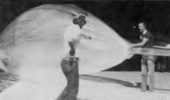
Historical Note: The name Stratosonde honors Environment Canada’s 1986 atmospheric research program. Read the Zephyr 1986 Environment Canada publication →
Community Resources:
- Picoballoon Group - Flight coordination & community tracking
- UKHAS - High altitude balloon documentation & tools
- Amateur Radio Networks - APRS tracking infrastructure
Repositories
- firmware - Core firmware for the radiosonde device
- ground - Ground station software and tracking
- hardware - PCB designs, schematics, and component information
- docs - Technical documentation site
- h3lite - Embedded H3 geospatial indexing for automatic LoRaWAN region detection
- .github - Organization profile and landing page
Open hardware for atmospheric science